


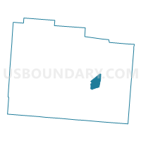
PRECINCT NEW JASPER 465, Greene County, Ohio
About
Outline

Summary
| Unique Area Identifier | 646778 |
| Name | PRECINCT NEW JASPER 465 |
| County | Greene County |
| State | Ohio |
| Area (square miles) | 3.82 |
| Land Area (square miles) | 3.82 |
| Water Area (square miles) | 0.00 |
| % of Land Area | 99.97 |
| % of Water Area | 0.03 |
| Latitude of the Internal Point | 39.67228220 |
| Longtitude of the Internal Point | -83.78774280 |
Maps

Graphs
Select a template below for downloading or customizing gragh for PRECINCT NEW JASPER 465, Greene County, Ohio


Neighbors
Neighoring Voting District (by Name) Neighboring Voting District on the Map
- PRECINCT CEDAR TWP 410, Greene County, OH
- PRECINCT NEW JASPER 466, Greene County, OH
- PRECINCT NEW JASPER 467, Greene County, OH
- PRECINCT ROSS TWP 475, Greene County, OH
- PRECINCT SILVERCREEK 426, Greene County, OH
Top 10 Neighboring County Subdivision (by Population) Neighboring County Subdivision on the Map
- Cedarville township, Greene County, OH (5,500)
- Silvercreek township, Greene County, OH (3,738)
- New Jasper township, Greene County, OH (2,568)
- Ross township, Greene County, OH (750)
Top 10 Neighboring Place (by Population) Neighboring Place on the Map
Top 10 Neighboring Unified School District (by Population) Neighboring Unified School District on the Map
Top 10 Neighboring State Legislative District Lower Chamber (by Population) Neighboring State Legislative District Lower Chamber on the Map
Top 10 Neighboring State Legislative District Upper Chamber (by Population) Neighboring State Legislative District Upper Chamber on the Map
Top 10 Neighboring 111th Congressional District (by Population) Neighboring 111th Congressional District on the Map
Top 10 Neighboring Census Tract (by Population) Neighboring Census Tract on the Map
- Census Tract 2601, Greene County, OH (6,250)
- Census Tract 2701, Greene County, OH (3,738)
- Census Tract 2801.01, Greene County, OH (2,568)